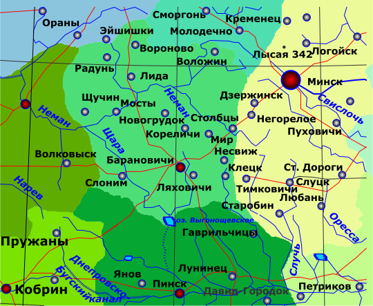
Baranovichi Region in 1940
Baranovichi District · Historical maps · 1940
Download
- SVG - vector map 83 KB
- SWF - original Flash file 16 KB
The Baranovichi Region existed from 4 December 1939 to 8 January 1954. In 1940 it covered 23,300 km² and was divided into 26 districts - from Lida and Valozhyn in the north to Lyakhovichi and Slonim in the south.
After the war the region shrank, and in 1954 it was abolished: its districts went to the Brest, Grodno, Minsk and Molodechno regions.
On the map 49
Барановичи, Бугский канал, Волковыск, Воложин, Вороново, Гаврильчицы, Давид-Городок, Дзержинск, Днепровско-, Клецк, Кобрин, Кореличи, Кременец, Лида, Логойск, Лунинец, Лысая 342, Любань, Ляховичи, Минск, Мир, Молодечно, Мосты, Нарев, Негорелое, Неман, Несвиж, Новогрудок, Ораны, Оресса, Петриков, Пинск, Пружаны, Пуховичи, Радунь, Свислочь, Слоним, Слуцк, Случь, Сморгонь, Ст. Дороги, Старобин, Столбцы, Тимковичи, Щара, Щучин, Эйшишки, Янов, оз. Выгонощевское